Your Professional Services team is composed of implementation specialists, project managers, IT technicians, and developers with extensive experience deploying GIS and GNSS technologies for mobile data collection.

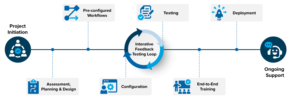
Project Initiation
In the first step, we collaborate with you to assemble a project team, create a plan, and ensure adherence to the agreed upon scope and schedule.
Assessment, Planning, and Design
Next, we evaluate current systems, review future design criteria, and engage stakeholders from various departments. This includes understanding all integrations including GIS, IT and security infrastructure, hardware devices, hosted environments, asset management, and work order management systems
Preconfigured Workflows
You benefit from our “out of the box” pre-configured workflows refined from years of industry experience. These workflows address core requirements for gas distribution, regulated pipelines, leak detection & repair, and pipeline inspection, repair & maintenance while allowing for client-specific customizations.
Configuration and Testing
We utilize Agile project management and configurable intelligent forms to swiftly configure and test your field data collection solution. This ensures constant, immediate feedback, allowing for greater adaptability and higher productivity while meeting your business requirements.
End-to-End Training
Once your CartoPac solution is deployed, your team receives comprehensive training tailored to match your needs. From the field to management and administrative roles, our training approach ensures smooth adoption of your CartoPac solution.
Deployment
In preparation for deployment, we work with you to effectively communicate and manage change as users transition to the new solution. Whether deploying to a small team or a large enterprise, our focus remains on making your CartoPac solution successful and user-friendly for all levels of your organization.
Support
Finally, we ensure the longevity and relevance of your solution with our maintenance services. Our team provides ongoing support to keep your solution evergreen, allowing you to focus on your core operations.

As a pipeline operator or utility company you have your own complex construction management needs. That is why we offer custom configurations to exceed your expectations and provide the exact solution you need.
No matter how unique or exceptional your location or project is, CartoPac offers one-of-a-kind features and tools to address your requirements.
Your Trusted Data Partner
We support you every step of the way to ensure your data is traceable, verifiable, and complete.
Integrations deliver your data where it needs to go, including enterprise systems of record such as GIS, Maximo, and SAP.
Thank you for your interest in the CartoPac Platform. Fill out the form below and we’ll be in touch as soon as possible.
"*" indicates required fields


